Sunday, November 20, 2011

Nottingham Colliery

The Nottingham Colliery was located in Plymouth, behind the Family Dollar and along Nottingham Street. Foundations, a basement, various concrete footers, two buildings, and a fan house/shaft house foundation along Shawnee Avenue are all the remain of the colliery today. This colliery dates back to 1865, when the Nottingham Coal Company was founded. Shortly after obtaining a lease from the Reynolds family of Plymouth, a coal breaker was constructed and a 380 foot shaft was sunk. Over time, the owners would change. On April 1, 1872, the lease to the colliery was sold to Lehigh Navigation & Coal Company and on January 1, 1874 it was then sold to Lehigh & Wilkes-Barre Coal Company, which under their lease it was called the Nottingham No. 15 Colliery. Sometime in 1904, a new breaker was constructed to replace the old one, which was built on the shaft. The colliery ended it's operations when the second breaker was demolished in August of 1936, the mines were still mined until the 1950s and the coal was shipped to the Lance Breaker to be processed.
The first breaker (left) and the second (right) still under construction in 1904. These lands have changed drastically since this photo was taken. 
Today a church and its parking lot now stand where the breakers once stood. The two buildings that stand now house Campas Collision.
The church and Campas Collision in view. 
Campas Collision now houses in this building.
A close up of the front of this building reveals the words: Nottingham Coal Works 1866 engraved onto it.
The second building that still stands. If you look at the post card on the top of the page, you can see the first building but not this one standing. Perhaps this one was built at a later date?

Various concrete pieces dumped in the woods, across from the church.

The rest of the remains are in a small wooded area behind the Family Dollar. The engine house foundation, boiler house foundation and basement, and an unknown building foundation remain. A large mound of fill can also be seen. That is where the slope was. I'm unsure when it was filled.

Looking at the fill, where the slope is located, from the foundation of the engine house.
The foundation to the engine house. The boiler house foundation and a home can be seen in the background.
A close up of the engine house foundation. A cut out can be seen and was most likely where part of the engine rested upon.
Some bolts can be seen sticking out of the ground from the engine house.

Just next to this foundation is another, much larger, foundation. I am unsure what building it may of been. This foundation can be seen from the parking lot of Family Dollar.

The foundation to the unknown building as seen from the parking lot. The trees growing there have caused those walls to come down.
Part of the foundation that has cut outs in it. Something most likely attached here.
The rest of this foundation is basically flat and only has some bolts sticking out of the walls every now and then. From here, the boiler house foundation can be seen, it can be seen from the engine house foundation as well.

The boiler house foundation as seen from the engine house foundation.
The boiler house foundation as seen from the unknown building foundation. The opening into the basement can be seen.
 From here, you can see the basement opening, which was filled at one point, which is why that mound is there. The basement opening looks like a poorly filled slope entrance. Between the two foundations and the boiler house foundation are many concrete footers laying about, some with metal sticking out of them still.

Pieces like this lay about and just beg for someone to trip over them.
After a short walk of avoiding those and thorns, the basement can be accessed.

A close up at the basement entrance.
Looking inside the basement.
Once inside you can see light coming in from the left. It may of gone that way but is collapsed. To the right, it goes a little bit, with a brick roof. It is collapsed there and climbing up the rubble to the top of the foundation is the way out, but to the left, the continuation into the back part of the basement can be seen.

Just inside the basement, looking out.
Inside the basement with the brick roof. The opening is to the left.
Looking at the left part where the roof of the basement has collapsed.
Looking to the right, where the ceiling has collapsed. You can see part of one of the beams.
Once out of the rubble, a small opening, mostly filled from the collapse, is seen to the left.

This small opening is the way into the back part of the basement.
Once in there, there is a tiny hallway.

The tiny hallway that leads into the back part of the basement.
 Once inside the back part, it goes to the left and the right.

Looking to the right.
Looking to the left. Light comes in due to a collapse.

I'm unsure what the purpose to the basement was but on the ceiling are what appears to be hatches that opened up and on the walls are, what appears to of been, chutes of some sort. Perhaps soot was sent down here.

A close up at one of the possible chutes in the wall, now filled with rubble from the building.
A look at the possible hatch on the ceiling.
Looking down the tiny hallway to the outside.
There's not much in the basement except some garbage. A small walk from here and the collapsed portion of the foundation/basement can be seen.

The part of the boiler house foundation that is collapsed. The fence in the background is part of someone's yard.
A few blocks from all of this is the foundation to the fan house/shaft house for the Nottingham Colliery. This foundation is along Shawnee Avenue.

The foundation seen on a rainy day.
The various times I've been to the Nottingham, nothing has really changed. Within a few years though, I'm sure more of the boiler house basement will collapse though. These photos were taken during 2010 and 2011.

One last photo of the length of the basement, with the flashlight focused on the end of it.

Wednesday, October 26, 2011

Peach Orchard Vertical Shafts

The two shafts as seen from Bing Maps, look at the two "boxed" areas. Those are the fences that go around the shafts. If you look closely, you can see the shaft wall on the left one.
These two filled shafts were once part of the Peach Orchard Colliery. I don't have much information about this colliery and to my knowledge all buildings to it have been torn down. I was going to link on site on here that had photos of several buildings but the site is currently down but I remember it mentioned those buildings were torn down to make way for the extension of the North Cross Valley Expressway. So, as far as I know, these two shafts are all that remains to the Peach Orchard Colliery. It appears they were filled some time ago but the fill has been settling. The larger shaft has two openings. The purpose for that was so the miners and coal can be taken up to the surface at once, coal on one side and miners on the other side.

Looking over the fence at the one side of the double sided shaft. Due to the fill settling, you can see part of the wall.
The other side of the shaft. The fill has subsided much more on this side.
The other shaft is much closer to the road and you may drive right past it and not even know that it's a shaft.

The other shaft with Wilkes-Barre Boulevard and the North Cross Valley Expressway (309) in view. 
Looking down the filled shaft.
These photos were taken during December of 2010 and March of 2011. I'm sure since then, the fill has settled some more due to all the rain we've been getting.

Monday, October 24, 2011

Susquehanna Colliery No. 7

   
The colliery seen during operation.
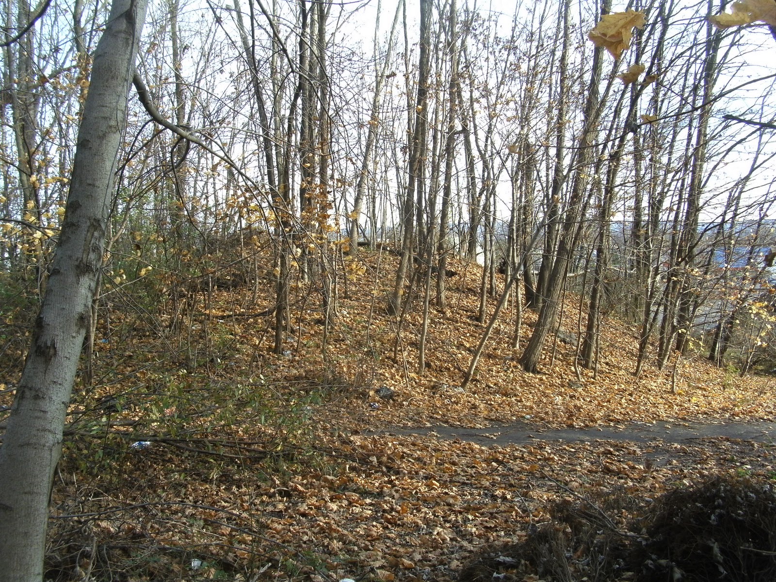
   This colliery was located off of Main Street in Nanticoke. The repair shop to this operation is the only full building intact and is still used, by a construction company now. Other remains are standing walls to the boiler house, the basement to the boiler house, coal pockets to the breaker, a brick tower to the breaker, a small tunnel and various concrete foundations all about. I don't know too much about this colliery. These photos were taken in the spring of 2011, except the first one.
A postcard showing the colliery during operation.


This is one of the first things spotted, providing you enter from Main Street. It's a mound of dirt with a thick cable resting on concrete foundations. If you look at the photo taken during the colliery's operation you'll see a shaft headframe in the distance. I think this may of been that shaft. 

Possible shaft?
Close up of concrete pieces and the cable.
Once you've gone passed that, there is an abundment on the hillside and two small concrete supports. It appears to been part of a bridge of some sort, probably rail related.

The abundment can be seen on the and the two concrete supports are right next to the path.
Once passed this, the remains of the breaker can be seen. All the remains is a brick tower and the coal pockets with various other remains laying about within them, mostly timbers.

The brick tower that was once part of the breaker.
The brick tower can actually be entered through an opening on the one side. It appears this had some sort of purpose based on the metal inside of it.

Inside the brick tower looking up.

Also, something else we discovered inside the tower, a tunnel. We didn't notice this until the second trip here.

At first glance, it just looks like the ground settling underneath the structure but this is the opening to a tunnel.
When we realized this was a tunnel, we got a shovel that was in the boiler house basement and dug into this just enough to fit down into it. It was rather muddy in this tunnel and the farther down you followed it, the muddier it got, due to it dumping at the nearby creek.

Looking down the tunnel. It goes for a bit before slanting to the right and dumping into the creek.

A pipe that comes out of the wall at the beginning of the tunnel which suggest that waste from the colliery was sent to this tunnel to be dumped into the creek.
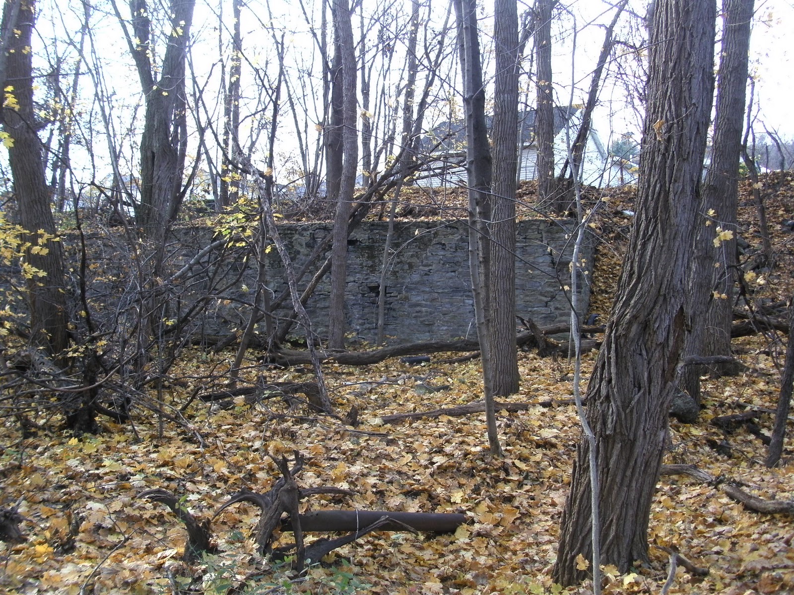
Going up the hill, towards the boiler house, there are many different various concrete foundations about. The one concrete piece that has the year 1921 engraved on it I believe to be a filled slope entrance. Just behind it, up the hill, the ground is subsided rather badly so if it is a slope, it's collapsed just inside, making it not worth digging to get into. 

Close up at the wall I believe to be a slope entrance.
After this is where the remains of the once massive boiler house stands. If you looked at the first photo, the boiler house is that long building with all the smoke stacks.

Bricks lay everywhere from the boiler house and that concrete section is all that stands.
Not much of this structure stands today but it's still interesting to look at, despite very little remaining.

Close up of the year 1913 engraved on the remaining part of the boiler house.
A look "inside" the remains of the boiler house.
On the other side of this is an opening that goes under where the photo just above this sentence was taken.

The back of the boiler house with the tunnel in view. I apologize for the blurriness of this photo.
At the end of the tunnel looking outside.
The most interesting thing about this boiler house isn't even what is outside. There are several openings on the outside that go into the basement.

The beginning of the basement.
Once inside the basement, a short walk takes you to this pipe with valves on it.

I'm really unsure what this did but it's an interesting find.
Once you get to this, the basement turns right and light can be seen coming from the outside.

A pile of rubble along the wall inside the basement.
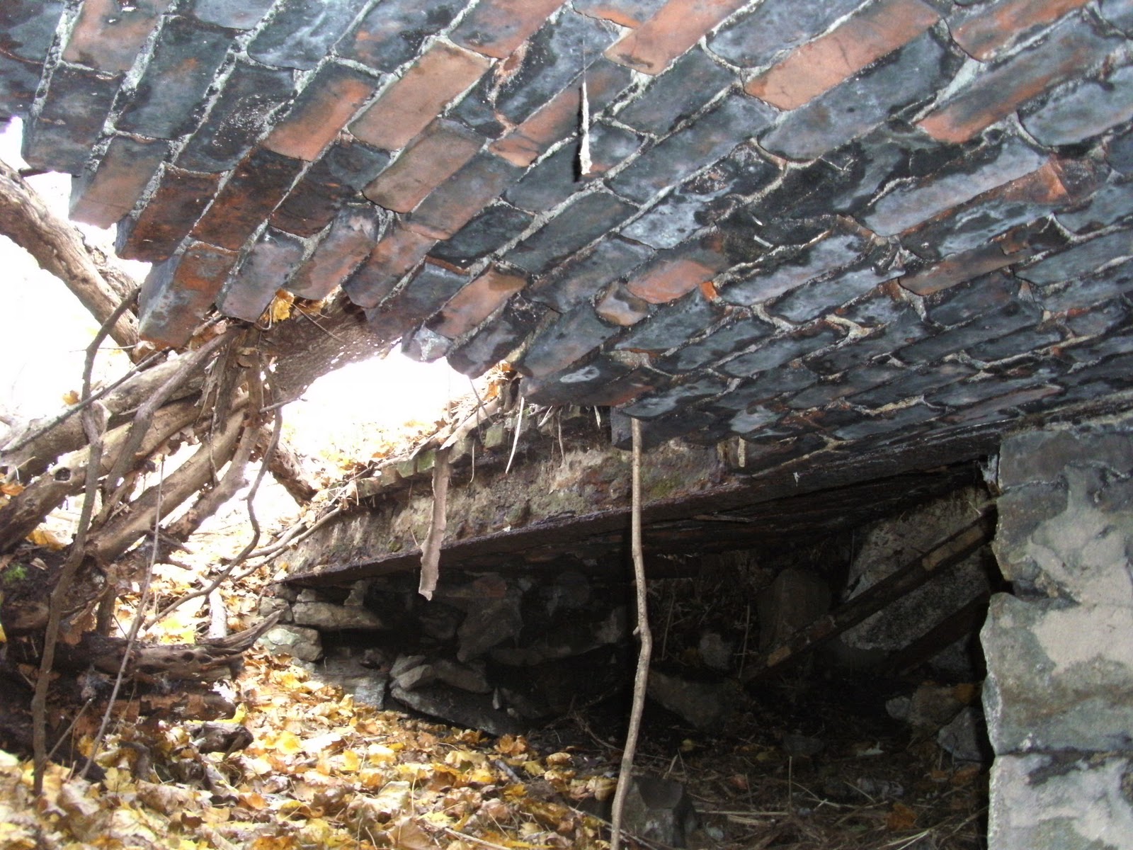
What can't be seen in that last photo is, in my opinion, the most interesting thing on this site, a tunnel that is to the left. The tunnel is smaller than the rest of the basement, 5 to 5 1/2 tall, and it's narrow, but it's made out of brick, nothing but brick, and it's solid.

The end of the tunnel looking back.
The tunnel is about the length of the boiler house, about 90 feet long. It ends because of a pile of bricks blocking the path. After examining the area above this, it appears the tunnel stopped there but when the building was torn down, bricks were pushed into the tunnel opening. Inside the tunnel are pipes that appear every now and then and soot.

The end of the tunnel is met with bricks that look like a collapse, beer cans (no surprise there) and other junk.
This tunnel, I have to say, is probably the safest underground structure I've been in. The bricks are all solid and are still held rather tight. The repair shop that is now used by a construction company can be seen from the remains of the boiler house.

The back of the repair shop with some boiler house remains in view.
It may be hard to see, but a set of stairs leads up to the repair shop from the boiler house.
  Another thing on this colliery site is a small tunnel, along a hillside, that looks like a slope entrance. The tunnel was for a conveyor and the reasoning for it going underground for about 30 feet is because a train line ran on top of the tunnel.  

The small conveyor tunnel has no signs of a conveyor even in it, probably was all scrapped.
A close up of the top reveals the year 1910, but if you look closely at the 0, there appears to of been a piece in the center that has eroded away, making the 0 an 8, thus it having the year 1918.

Also, if you look at the outline, it slants it a bit at the center on both sides, like an 8 would do.
The other side of the conveyor tunnel.
A farther view of the other side of the conveyor tunnel.
Near this was another interesting find, an abandoned pole standing with this tag still on it: 


  The two trips we had here were rather successful, except my camera dying on the first one. There are many different years engraved on various pieces of concrete, the latest that I found so far was 1940. These photos were taken in April of 2011 and we haven't been there since so I'm unsure if anything has changed. If so, I will put up an updated article about those changes.

A last look at the brick tower from the breaker before leaving.